Bountiful rains soak Telangana
20-07-2025 12:00:00 AM
- Telangana faced 28% rainfall deficit from June 1 to July 15, with GHMC areas worst hit at over 50% shortfall.
- Lack of low-pressure systems near Bay of Bengal blamed for early monsoon failure, says IMD expert.
- Rain makes a comeback! Widespread showers lash the state from July 17 to 19, bringing relief across districts.
- Forecast upbeat: Active monsoon phase to continue for next 4-5 days across most of Telangana.
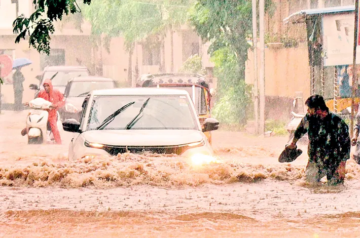
After enduring a prolonged dry spell for nearly 45 days, Telangana has finally witnessed a welcome turnaround in the form of widespread rainfall since July 17. The sudden shift has brought relief to both citizens and farmers, especially across the Greater Hyderabad region, which had suffered the brunt of a deficient monsoon.
According to data from the Indian Meteorological Department (IMD), Telangana recorded a 28% deficit in cumulative rainfall between June 1 and July 15, marking one of the driest early monsoon phases in recent years. The GHMC limits — encompassing the Hyderabad, Ranga Reddy, and Medchal-Malkajgiri districts — faced a particularly severe dry spell, with rainfall deficit crossing 50 to 60% during this period.
While most parts of India, particularly Northern India and the West Coast, experienced an active monsoon, Telangana — along with adjacent regions like Vidarbha, parts of Maharashtra, and Karnataka — remained largely untouched by rain-bearing systems.
Explaining the unusual trend, GNRS Srinivas Rao, Meteorologist, IMD Hyderabad, said, “This was due to the lack of any significant synoptic feature in the Bay of Bengal close to Telangana. Usually, during the monsoon, low-pressure systems or upper air cyclonic circulations form in the west-central Bay off the north coastal Andhra Pradesh. These systems reduce the monsoon wind speeds and help accumulate moisture over nearby land areas. But this time, the 2-3 low-pressure systems that did form were too far away — near Gangetic West Bengal — and hence Telangana got only scanty rainfall.”
Although the Southwest Monsoon in Telangana spans 122 days (June 1 to September 30), with occasional spill over into early October, the early onset of the monsoon in late May had initially raised hopes. However, the momentum fizzled out quickly, and the state saw little to no rainfall for over six weeks until mid-July.
In a dramatic shift, the last three days (July 17–19) have seen a substantial revival in monsoon activity, with heavy downpours across Southern, Central, and parts of Eastern Telangana. Most areas under the GHMC limits received between 5 to 10 cm of rainfall, bringing much-needed respite to urban and rural populations alike.
Shedding light on this abrupt change, Srinivas Rao stated,“The current spell of rain is due to the formation of an upper air cyclonic circulation near south coastal Andhra Pradesh at a height of 4.1 to 5.8 km above mean sea level, along with an East-West trough around 13 degrees North latitude. These synoptic systems are now helping to generate good rainfall over parts of Telangana.”
Looking ahead, the IMD forecast indicates that this active phase is likely to continue for another 4 to 5 days, with most districts of Telangana expected to receive moderate to heavy rainfall.
With major rivers like the Godavari and Krishna brimming with water thanks to heavy rains in upstream regions, and Telangana’s monsoon finally showing signs of revival, the state hopes to see more balanced rainfall distribution in the weeks ahead.